About Global Mapper Mobile
Bring your GIS workflow to the field. Global Mapper Mobile(R) is a powerful iOS application for viewing and collecting GIS data. It utilizes the GPS capabilities of mobile devices to provide situational awareness and...
Bring your GIS workflow to the field.
Global Mapper Mobile® is a powerful iOS application for viewing and collecting GIS data. It utilizes the GPS capabilities of mobile devices to provide situational awareness and locational intelligence for remote mapping projects. A perfect complement to the desktop version of Global Mapper, the mobile app provides maps-in-hand functionality for engineers, surveyors, wildlife managers, foresters, and anyone whose job requires access to spatial data in remote locations.
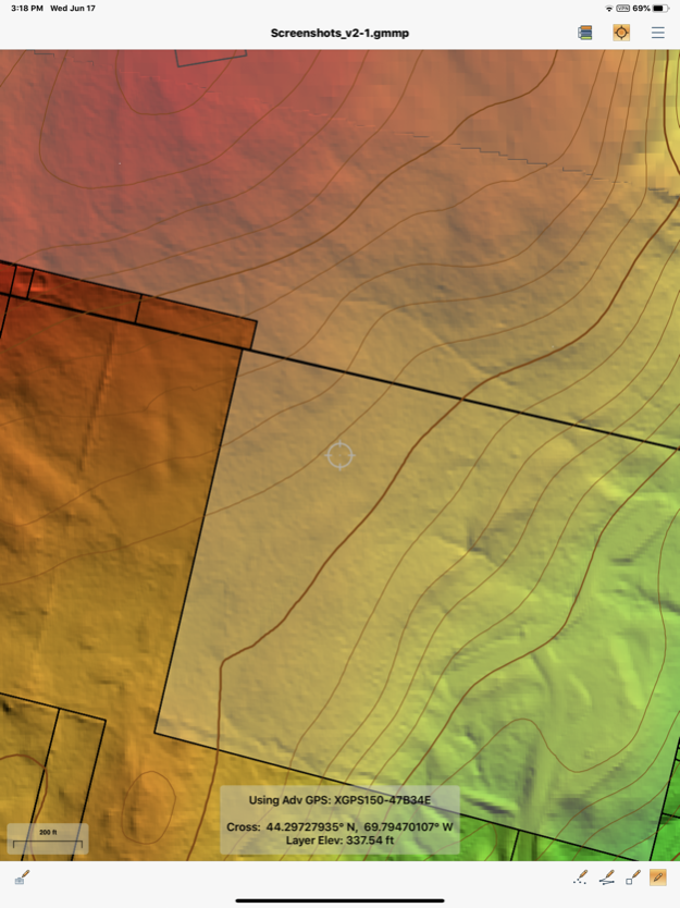
Global Mapper Mobile can display vector, raster, and elevation data layers that have been transferred from the desktop version of the software. It also provides tools for drawing, tracking, and form-based data collection using pre-configured attributes and picklists.
Global Mapper Mobile Base Version (Free)
The base version of Global Mapper Mobile is free of charge and provides an array of features and functions, including:
• Vector, raster, and terrain data display
• GPS location display
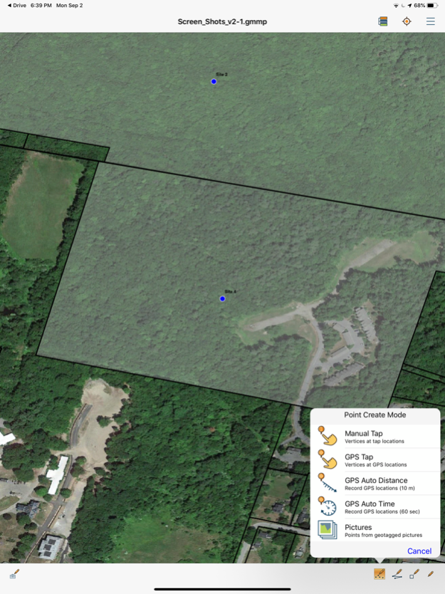
• Point, line, and polygon feature creation using GPS location
• Editing of existing vector features
• Capture of images in the field
• Creation of Picture Points from geotagged images
• Attribute and feature notation recording for new or existing vector features
• Online access to Open Street Map data
Global Mapper Mobile Pro
The Pro version of Global Mapper Mobile, available as an in-app purchase, supplements the functionality of the base version with an array of professional-grade tools, including:
• Advanced GPS support for connection to high-accuracy GNSS devices from vendors such as Bad Elf, EOS, Juniper, and others
• RTK correction via built-in NTRIP client
• GPS Averaging
• Terrain shader and water level display options
• Custom online source options and online data saving for offline use
• Simultaneous feature creation
• Viewshed creation
• Volume calculation
• Data reprojection
• Address searching
• Geopackage and GeoPDF format support
Global Mapper Mobile Pro is available as an in-app purchase. The license is based on an annual subscription from the date of purchase that can be renewed each year. Enterprise licensing options are also available. For more information, email
[email protected].
Note: Continued use of GPS running in the background can dramatically decrease battery life.
Privacy Policy:
https://www.bluemarblegeo.com/privacy-policy/
Terms of Use:
https://www.bluemarblegeo.com/licensing-policy/
Mar 26, 2024
Version 2.4.12
Global Mapper Mobile Standard (Free)
• New Raster Info tool to display pixel value for raster elevation or image data layer
• Added digitizer trace mode for manual line feature creation
• New option to record elevation for loaded terrain data to point features
• Improved vector, raster, and terrain data render speeds
• Dark Mode improvements
Pro Subscription
• Support viewshed calculation from the current GPS location
• Save the viewshed point and create the viewshed area as vector features in the map
• Expanded volume calculation options to include pile volume and vertex elevation methods
• Added support for Trimble GNSS devices
Previous Versions
Here you can find the changelog of Global Mapper Mobile since it was posted on our website on 2016-11-03 06:09:55.
The latest version is 2.4.12 and it was updated on 2024-04-22 09:05:18. See below the changes in each version.
Global Mapper Mobile version 2.4.12
Updated At: 2024-03-26
Changes: Mar 26, 2024
Version 2.4.12
Global Mapper Mobile Standard (Free)
• New Raster Info tool to display pixel value for raster elevation or image data layer
• Added digitizer trace mode for manual line feature creation
• New option to record elevation for loaded terrain data to point features
• Improved vector, raster, and terrain data render speeds
• Dark Mode improvements
Pro Subscription
• Support viewshed calculation from the current GPS location
• Save the viewshed point and create the viewshed area as vector features in the map
• Expanded volume calculation options to include pile volume and vertex elevation methods
• Added support for Trimble GNSS devices
Global Mapper Mobile version 2.4.9
Updated At: 2023-08-23
Changes: Aug 23, 2023
Version 2.4.9
Global Mapper Mobile Standard (Free)
• New Raster Info tool to display pixel value for raster elevation or image data layer
• Added digitizer trace mode for manual line feature creation
• New option to record elevation for loaded terrain data to point features
• Improved vector, raster, and terrain data render speeds
• Dark Mode improvements
Pro Subscription
• Support viewshed calculation from the current GPS location
• Save the viewshed point and create the viewshed area as vector features in the map
• Expanded volume calculation options to include pile volume and vertex elevation methods
• Added support for Trimble GNSS devices
Global Mapper Mobile version 2.4.8
Updated At: 2023-08-01
Changes: Aug 1, 2023
Version 2.4.8
Global Mapper Mobile Standard (Free)
• New Raster Info tool to display pixel value for raster elevation or image data layer
• Added digitizer trace mode for manual line feature creation
• New option to record elevation for loaded terrain data to point features
• Improved vector, raster, and terrain data render speeds
• Dark Mode improvements
Pro Subscription
• Support viewshed calculation from the current GPS location
• Save the viewshed point and create the viewshed area as vector features in the map
• Expanded volume calculation options to include pile volume and vertex elevation methods
• Added support for Trimble GNSS devices
Global Mapper Mobile version 2.4.7
Updated At: 2023-07-18
Changes: Jul 18, 2023
Version 2.4.7
Global Mapper Mobile Standard (Free)
• New Raster Info tool to display pixel value for raster elevation or image data layer
• Added digitizer trace mode for manual line feature creation
• New option to record elevation for loaded terrain data to point features
• Improved vector, raster, and terrain data render speeds
Pro Subscription
• Support viewshed calculation from the current GPS location
• Save the viewshed point and create the viewshed area as vector features in the map
• Expanded volume calculation options to include pile volume and vertex elevation methods
• Added support for Trimble GNSS devices
Global Mapper Mobile version 2.3.14
Updated At: 2023-03-28
Changes: Mar 28, 2023
Version 2.3.14
Added mesh bounds to Projection Configuration view
Added Inferno, Magma, Plasma, Viridis, and REM shaders
Added URL test/verification for custom online data sources
Fixed online data layer transparency
Fixed zoom behavior of single point layers
Fixed issues with viewing embedded images
Fixed issue with custom feature styles in template layers
Global Mapper Mobile version 2.3.7
Updated At: 2022-07-26
Changes: Jul 26, 2022 Version 2.3.7
What’s New - Version 2.3
• Saving multiple pictures to a feature - Take and save multiple pictures associated with a given feature.
• Record Voice Memos - When creating a feature, a voice memo can be recorded and associated with the feature.
• Autosave - An automatic backup file is created every five minutes when changes are made to an active GMMP.
Advanced Features (Pro Module Only)
• Advanced GPS now supports TCP/IP Communication - Connect to any GNSS device which supports communication over TCP/IP.
• Volume Calculation - Users now have the ability to calculate volume, from a preloaded area feature or from an area feature created in the field.
• View Shed - Calculate a view shed from point features recorded in the field.
• Native support for UTM and SPCS projection - Newly added native support for UTM and SPCS-based projections
Global Mapper Mobile version 2.2.17
Updated At: 2022-02-15
Changes: Feb 15, 2022 Version 2.2.17
Now supports Global Mapper Mobile Data Management tool. Tool available in Global Mapper 23.1 and later.
Global Mapper Mobile version 2.2.11
Updated At: 2021-07-27
Changes: Jul 27, 2021 Version 2.2.11
• Compass Display - An optional compass can be displayed on the screen to provide information on the user’s bearings while navigating in the field.
• Improvements to dynamic attributes when digitizing - Users now have control over adding timestamp and GPS-based attributes (location, accuracy, etc.) to features when digitizing.
• Elevation Accuracy available for GPS Information display - Users can now display elevation accuracy on the GPS Information display. Note: Some older hardware may not report this information.
• Location icon customization - Customizable location icon to suit a wider variety of use cases while in the field using built-in options.
Advanced Features (Pro Module Only)
• Advanced GPS Support now supports select RTK GNSS units - Use the built-in NTRIP client to connect to your correction source directly within Global Mapper Mobile. Location Information has been redesigned and will now display RTK information as well - even if you’re using an external NTRIP client.
• Create multiple features at once - For example, mark waypoints during the recording of a track.
• Show coordinates in projected units - Find an address’s location and create a point to represent it. This functionality requires a data connection.
• Strike and dip feature creation - Ability to create strike and dip features on devices with appropriate sensors (magnetic, accelerometer/gravity).
Global Mapper Mobile version 2.2.9
Updated At: 2021-07-13
Changes: Jul 13, 2021 Version 2.2.9
• Compass Display - An optional compass can be displayed on the screen to provide information on the user’s bearings while navigating in the field.
• Improvements to dynamic attributes when digitizing - Users now have control over adding timestamp and GPS-based attributes (location, accuracy, etc.) to features when digitizing.
• Elevation Accuracy available for GPS Information display - Users can now display elevation accuracy on the GPS Information display. Note: Some older hardware may not report this information.
• Location icon customization - Customizable location icon to suit a wider variety of use cases while in the field using built-in options.
Advanced Features (Pro Module Only)
• Advanced GPS Support now supports select RTK GNSS units - Use the built-in NTRIP client to connect to your correction source directly within Global Mapper Mobile. Location Information has been redesigned and will now display RTK information as well - even if you’re using an external NTRIP client.
• Create multiple features at once - For example, mark waypoints during the recording of a track.
• Show coordinates in projected units - Find an address’s location and create a point to represent it. This functionality requires a data connection.
• Strike and dip feature creation - Ability to create strike and dip features on devices with appropriate sensors (magnetic, accelerometer/gravity).
Global Mapper Mobile version 2.1.12
Updated At: 2020-06-27
Changes: Jun 27, 2020 Version 2.1.12
Advanced GPS (Pro Module only)
- Connect to external high accuracy Bluetooth GPS devices from vendors such as Bad Elf, EOS, and others
- Satellite Information view
- Detailed Location/Fix Information view
- NMEA Stream view and logging
Terrain Layers
- Terrain shader selection/change within the app (Pro Module only)
- Hill shading
- Water level display (Pro Module only)
- Display elevation at crosshair location
Vector Features
- Extended styling support
- Custom point symbols
- Style preview thumbnails
Raster layer transparency setting
Improved background color picker
Improved appearance in Dark Mode
Miscellaneous fixes and enhancements
Disclaimer
Official App Store Link
We do not host Global Mapper Mobile on our servers. We did not scan it for viruses, adware, spyware or other type of malware. This app is hosted by Apple and passed their terms and conditions to be listed there. We recommend caution when installing it.
The App Store link for Global Mapper Mobile is provided to you by apps112.com without any warranties, representations or guarantees of any kind, so access it at your own risk.
If you have questions regarding this particular app contact the publisher directly. For questions about the functionalities of apps112.com contact us.